Types of Paths
We advise park users to stay on their designated paths. In our parks and along our park connectors, you will encounter these types of paths:
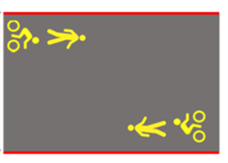
| Shared Path | Red continuous line. Dotted line when approaching attention zone |  |
This is shared by all park users, with a maximum speed of 25km/hr. You may see the path being flanked by red continuous or dotted lines (when users approach an Attention Zone).
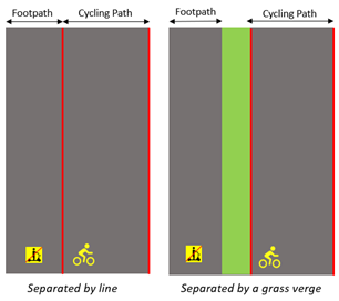
| Segregated / Separated Path |  |
At some locations, there are dedicated paths for various PCN users:
Footpaths - for pedestrians, cyclists and personal mobility aid users travelling at slower speeds (not more than 10km/h). Motorised PMDs and PABs are not allowed on the footpath. Cycling path – for PMD users and cyclists travelling at higher speeds. This path is flanked by continuous or dotted lines (when users approach an Attention Zone) in red, and feature “PCN” imprints or cyclist icons.
| Attention Zones |

Segregated paths may merge into ‘Attention Zones’ at key nodes (such as bus stops, crossing, fitness corners, playgrounds, toilets and plaza areas). These are demarcated by red dotted lines, indicating a shared area for all users.
Within Attention Zones, cyclists and PMD users should slow down and give way to pedestrians.
As users of the PCN, we would like to have a pleasant and safe experience while travelling. We can do this by being gracious and keep a lookout for each other.
Learn more about the PCN etiquette in the next tab!
Pilot for Revised PCN Typology Phase 2
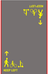
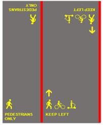
To better enhance the user experience along our Park Connector Network (PCN), the National Parks Board (NParks) started piloting a revised PCN typology in September 2022 that segregates selected stretches of the PCN into pedestrian-only paths (POP) and shared paths (SP). NParks also enhanced the clarity of paths through newly designed ground imprints that clearly reflect the user groups allowed on each path, as well as the user group that is accorded priority within each path.
Phase 1 of the revised PCN typology pilot was implemented between 2022 and 2023 for approximately 30km of park connectors along the Round-Island-Route Eastern Coastal Corridor and Pasir Panjang Park.
NParks will be implementing Phase 2 of the pilot progressively along the following park connector paths:
- Tanjong Rhu PC
- Gardens By the Bay
- Marina Barrage
- Singapore River Promenade
- Punggol PC
- Pasir Ris Park
- Ulu Sembawang PC
- Sembawang PC
- Bedok PC
- Ulu Pandan PC
| Shared Path | Segregated / Separated Path | |
|---|---|---|
 |
 |
Based on surveys and feedback, NParks has further improved the clarity of the ground imprints by including directional arrows for Phase 2. These complement the “Keep Left” PCN etiquette and guide users on which side of the path they should be using when moving in different directions. NParks will continue to work with LTA and other stakeholders to raise public awareness on the revised PCN typology and encourage good PCN etiquette.
NParks will review the outcome of the pilot, including public feedback received, before deciding if this revised typology should be refined further and implemented at other park connectors.

